Hiking & Mountain Biking Trails
Sandon is central to some of the most stunning trails in the Selkirk Mountains. Stay a few days and enjoy the numerous hiking and biking trails in our area.
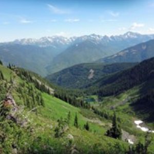
Idaho Peak
|
Idaho Peak
This is a beautiful place to view alpine flowers during July and August. The road begins in Sandon and climbs past sights of lakes, valleys and old mine-sites. Idaho Peak is at 7479 feet and the alpine meadows lie at the 12 kilometer mark where a parking lot is located. Be sure to bring a camera and take out what you bring in. A 2 kilometer hike along a ridge takes you to the summit where you will see the villages of New Denver, Silverton and Rosebery. It is a great bird’s eye view of the Valhalla mountain range and Slocan Lake. The road to Idaho Peak is not a road for motor-homes or vehicles with trailers or low clearance. It is generally open from July to September. Trail Map |
|
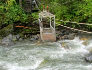
The Galena Trail
Access at Three Forks is from Sandon Road, at the junction with Highway 31A (8km east of New Denver). Converted from the old Nakusp & Slocan Railway line, the Galena Trail is a beautiful, non-motorized recreation trail which covers 13 km from Rosebery to Three Forks (at the Sandon turnoff). The trail connects to a local network of other trails, and features an easy grade, a lakeshore section, cable car over a creek, picnic tables, and historic sites. It makes for excellent hiking, mountain biking, cross-country skiing and snowshoeing. Hook your bike onto the small cable car that crosses Carpenter Creek at the old Alamo mine site, where you can see the remains of the old concentrator. Uphill from the concentrator is a derelict old house. Hiking map |
|
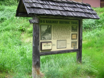
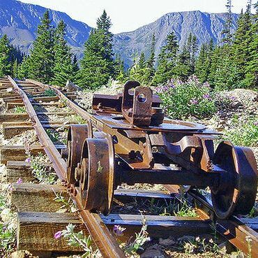
K&S Railway & Mount Payne Trail
The K & S Railway Trail can be done in many ways. No matter how you do it, be sure to give yourself time to poke around the old mine sites, admire the rock work and pause to take in the views. If you want a bit of a workout, start at Three Forks. The first section of trail takes you to the old CPR grade. Follow this for 300 metres, then look for a sign that directs you to the left and up, onto the old pack trail. After a steep 1.4 km you are at Payne Siding. Turn left to Payne Bluff, which is 300 metres along the railway grade. Biking? The first 2.5 km from Sandon is a pleasant family bike ride. After this, the trail becomes single track and somewhat technical. Hiking Map |
|
Wagon Road
This trail begins at the top of Zwicky Road in Kaslo and continues all the way to Bear Lake, headwaters of the Kaslo River. The majority of this trail is wide and has gradual incremental elevation gains. If you do not want to start at the beginning of the trail, this historical old highway and the old K&S Railway bed can be accessed from a variety of places along Highway 31A. After Fish Lake (30 km west of Kaslo) there is a 11 km highway trek, until you get to Three Forks by Sandon, where you can hook up to the Galena Trail. Th e Wagon Road is a wonderful trail to run, walk, mountain bike, snowshoe or cross country ski along, and is designated as an ‘all uses’ trail. |